Welcome to a divine place called Jeypore. The place is famous for its old palaces and the hills surrounded it. You can find it in google-maps.

In this blog I will try my best to bring the nature to live...
 Jeypore pronounced in Oriya as Joypur, literally means "the city of victory". Nature has given Jeypore generously waterfalls, dense green forests and the most beautiful and naive tribal folks (the original settlers).
 The Town has an ancient history which begins with the removal of the capital of the kingdom from Nandapur to Jeypore during the rule of Shri Vira Vikram Dev (1637-69 A.D.). The ruins of Maharaja's old fort and a great tank called Jagannath Sagar, about a mile long and half a mile wide which never dries up, can now be seen inside the town.
 How to Reach
AIR: - 220 kms, nearest airport is at Visakhapatnam and 521 kms, from Bhubaneswar.
RAIL: - Jeypore is a railhead on the S.E. Railways. Albiet if you are coming from Vishakapatnam there is a Vishakapatnam Kirandol passenger train which gives you a picturesque and fatigue free journey which takes you along the winding hills of Koraput. You would also come across the Semiliguda railway station on the way.
ROAD: - On the N.H. No. 43, it is connected by regular bus services from Bhubaneswar, Berhampur and other important places of the state.
Places to Visit

JEYPORE
The city of victory and the palace of erstwhile Jeypore estate. The old fort is incircled by high masonary wall with an imposing gateway. A mile and a half wide great water tank, west of the town, known as Jagannath Sagar, is ideal for water sports. Jeypore, developed as the center of trade in Koraput district, is also famous for paper mask crafts.
GUPTESWAR
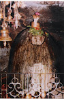

60 kms. from jeypore. The place is famous for the cave shrine of Lord Shiva located at the top of a limestone hill which is about 151 mts higher than the surrounding beautiful countryside, the place is ideal for natural scenery. One can reach the cave by ascending a flight of steps. Popularly known as Gupta Kedar in the vicinity, this sacred place is associated with Shri Rama of the epic Ramayana. The nearby hill has been named "RAMAGIRI".
SABARA SRIKHETRA (KORAPUT)
Koraut situated 2,900 ft. above sea level. Also known as “Sabar Shrikshetra”, the modern Jagannath Temple has come up on a hilltop.The Tribal Museum behind the temple caters to and educates the tourists about the culture and heritage of the tribals.
KOLAB

KECHELA, a small island near kolab garden.
 This place is surrounded by water (kolab river). The only way to reach there is by boat. It takes more than 30 mins to reach there.
Below is a video taken from the top of the kechela.
 DUMRIPUT
 A village stands between Koraput and Sunabeda by the side of NH 43. The famous Sri Ram Temple situated in the locality is widely known for the highest kneeling Hanuman Statue in Orissa. Shree Ram Navami festival is popularly celebrated every year which attracts a large number of devotees.
DUDUMA (MACHHAKUND)

70 kms from Jeypore, known as Matsya Tirtha, Machhakund is a place of pilgrimage as well as a centre of HydroElectric Project for the waterfall here (157 mts). A beautiful township amidst deep greenery of nature has developed around the project. It is also a place of pilgrimage and is associated with the name of shri Chaitanya who is believed to have visited this place in the early part of 16th century.
BAGARA
It is famous for waterfalls. The place is reached on kutcha road for 3 miles from Khondaguda which is 10 miles from Koraput and 6 miles from Jeypore. There are three small waterfalls from a height of about 30 ft. on the river Kolab. The place is surrounded by beautiful natural scenarios. It has a rest house at the site of the falls for use of the visitors.
BALIMELA
102 kms, Balimela is a small village in the Mallkangiri subdivision of Koraput district. It has come to lime light with the establishment of Balimela HydroElectric Project. A dam has been constructed on the river Sileru at Chitakonda, 35 kms from Balimela. JOLAPUT: 96 kms, Jolaput is known for its newly constructed Dam and Reservoir. It is an ideal picnic spot.
NANDAPUR
A village in Pottangi Taluk 14 miles from Semiliguda on the road leading to Pawda , It is the headquarters of a police station and of community development block each bearing the same name. The ruins of a famous throne of 32 steps on which the early ruling chiefs of Jeypore were believed to be installed are also found in the village.
MALIGUDA
BOIPARIGUDA
It is a small village, its name being probably corrupted form of Bepariguda, meaning traders settlement situated within Jeypore Taluk nearly 14 miles from Jeypore on the roads to Malkangiri. It is famous as a trade centre. A manufacturing centre of bamboo matting has been opened in the village to develop cottage industry in the area. About 2 miles from this place, is a small village named kendupoda which is known for the shrine of a forest deity called Birukhomb, held in great reverence by the local people. It is said that the deity, when invoked, can kill or save any human being.
So many places still to be discovered...-----------------------------------------------------------------------------------------------------------
Here goes my second post on Jeypore - Nature's Own, a tour to scenic beauty places in and around Jeypore.
PATRAPUT
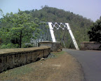 This place is nurtured with scenery views. Only 11kms from Jeypore on the way to Gupteswar. Can viewable @ wikimapia (patraput). In winter season this place feels like heaven on the Earth. The bridge shown in the picture is Iron made, and is a very old bridge. Both the sides of the bridge there nice places to have adventures for a day.
CHITRAKUT
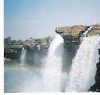
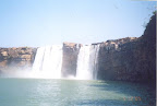 Holy Land of Lord Ram, about 100kms from Jeypore. Chitrakot (alternative spelling Chitrakut) is a waterfall on the Indravati River, located near Jagadalpur, Chhattisgarh. This river is a tributary of Godavari River. The height of the fall is 100 feet. The breadth of the waterfall varies as the water level in the river goes down drastically during summer. (wikipedia)
 A nice snap from http://www.trekearth.com/gallery/Asia/India/photo163762.htm.
-----------------------------------------------------------------------------------------------------------
Deomali, highest peak mountain of Orissa, 1672 meters (5485 Feet) above sea level. It's situated in Koraput District. Around 70 kms from Jeypore. This is near to Kunduli village(17 Kms). (Jeypore-> Koraput-> Sunabeda-> Similiguda-> Kunduli-> Deomali). So, Jeypore to Kunduli is NH-43 and then 17 kms It will be village road. But trust me road is not so bad. Only 3-4 kms road is bad (Under Construction). It will be a stiff ghat road(7-8 kms), so better travel with ruff&tuf vehicle. Here are some snaps from top of Deomali.
 |
 |
 |
 |
 |
Best Season to travel there is from October to January.
And here are some snaps on the way to Deomali.
A Best trip I ever had, enjoy the journey as well as the destination!
 |
 |
 |
 |
A video clip posting below to feel deomali virtually.
10 comments:
hey saroj...i got a complain to make..its been 3 months since i left jeypore(the max duration till date) and ur blog really made me homesick...seriously though its cool work, depicting the beauty of our own jeypore..when u get time pls add places such as deomali(highest mountain peak)..really this is how nature smiles...
hi Saroj...
awsome work man...one suggestion from me...u can add some photos of ratha yatra and dasahara of jeypore...and also v.d. college's photo after all its one of the oldest college of orissa...
still great work man...
thanks...
have some photos? send it across.
id is: saroz(dot)kumar(at)gmail(dot)com
I need photos of deomali, patraput, and any other place whih I forgot to mention...
good work.Nice to see nice places from orissa on net.I know ther r far better places in orissa than karnataka or tamilnadu/kerla..but we dont have enuf info available for ppl to visit them..
hi saroj great work man...it ws really heart-touchin to c my land compiled so beautifully n elaborately hats of to u man...but this only a glimpse of wat jeypore really is....its a natures wonder n v r the lucky few to b born there...
Rocking pics...especially Deomali's.....Planning a trip soon...
Hey Saroj...
Please add some photos of rathayatra,dasahara and some jeypore's own photo(like main road, some streets, jagannath temple......)
Wonderful. My child hood days were brought alive. Could you please tell me the name of the mountain on the East of Jeypore with a pillar at the top?
Is it the naatidangoro hill? behind govt. boys high school!!!
Post a Comment